In the vast theater of the Atlantic, hurricanes often take days—sometimes weeks—to reach their full fury. But every so often, nature delivers an event so astonishing that even seasoned meteorologists pause in awe. Hurricane Erin has entered that rare category. What began as a struggling tropical disturbance transformed into a powerful Category 5 hurricane in less than 25 hours, marking one of the fastest cases of rapid intensification ever observed in the Atlantic Ocean.
This blog explores Erin’s extraordinary development, the science behind its rapid growth, the impacts it has already unleashed, and what its story tells us about the broader challenges of our warming climate.
Meteorological Background: The Birth of Erin
Erin’s journey started humbly as a tropical wave off the coast of Guinea on August 9, 2025. For several days, it meandered westward across the Atlantic, hindered by dry Saharan air and marginal conditions. On August 11, the disturbance organized enough to be classified as a tropical storm. At first, it appeared to be an unremarkable system.
For much of mid-August, Erin’s structure showed little improvement. It wasn’t until August 15 that it finally achieved Category 1 hurricane status. Then, almost without warning, Erin ignited into something historic. Within hours, it leaped to Category 2, then Category 4, and by the morning of August 16, it peaked at Category 5 intensity. Sustained winds reached 160 mph (257 km/h), while its central pressure plummeted to around 915 mb—a classic fingerprint of explosive deepening.
What stunned scientists most was not just the peak strength but how quickly it happened. Erin compressed a process that usually takes days into little more than one.
A Rare Meteorological Feat
Erin’s transformation into a Category 5 hurricane in under 25 hours places it among the fastest-intensifying storms in Atlantic history. Even more remarkable was the timing. Historically, Category 5 hurricanes are rare before September, when the Atlantic usually enters peak season. Erin became the earliest Category 5 storm ever recorded in the open Atlantic, defying seasonal expectations.
Meteorologists called Erin’s intensification “astonishing,” noting that only a handful of storms have ever achieved such explosive growth so early in the calendar year. For context, only four other storms had previously reached Category 5 strength by mid-August in the Atlantic’s recorded history. Erin has now joined—and in some respects surpassed—that short list.
The Ingredients Behind Rapid Intensification
So what exactly made Erin intensify so quickly? Meteorologists use the term Rapid Intensification (RI) to describe situations where a storm’s winds increase by at least 35 mph in 24 hours. Erin far exceeded that threshold.
The following ingredients came together perfectly:
- Exceptionally Warm Ocean Waters
Sea surface temperatures in Erin’s path were well above average—hovering near 85 °F (29 °C). Warm water provides the fuel hurricanes need, releasing latent heat that powers the storm’s circulation. - Moisture-Rich Atmosphere
Dry air can choke off thunderstorms inside a hurricane, but in Erin’s case, the mid-level atmosphere was unusually moist, allowing convection to thrive. - Low Wind Shear
Vertical wind shear—the difference in wind speeds at different altitudes—was very low. This allowed Erin’s towering thunderstorms to remain vertically aligned and concentrate their power at the core. - Compact Structure
Smaller storms, like Erin initially was, can intensify more quickly because their cores are more sensitive to environmental changes. Once the eye wall tightened, the system spun up with explosive speed.
The “Stadium Effect”: Eyewall Architecture
One of the most mesmerizing features of Hurricane Erin was captured by the Hurricane Hunters who flew into its eye during peak intensity. They recorded a rare “stadium effect”—a phenomenon where the eye appears like the inside of a giant coliseum. The central sky was calm and sunlit, while massive walls of clouds rose like steep seating around it.
This phenomenon is not just visually stunning but scientifically valuable. It demonstrates that Erin’s core was extremely well-organized, a hallmark of the most powerful hurricanes. For forecasters, these visuals confirmed that the storm’s intensity estimates were accurate.
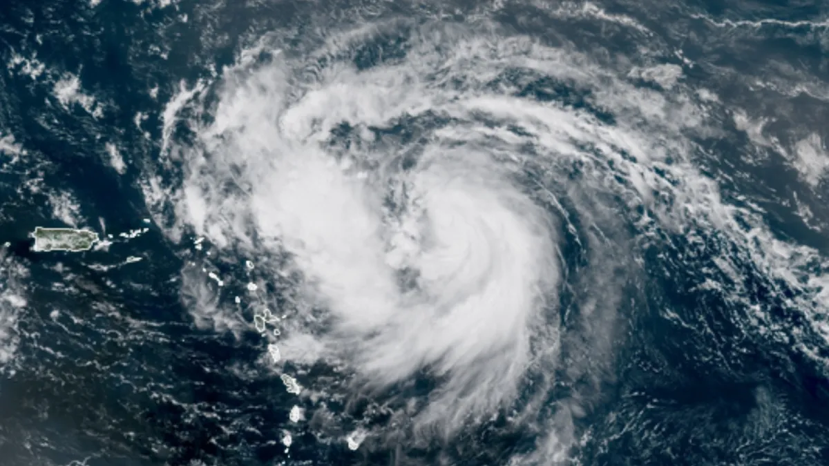
Impacts Across the Caribbean and Beyond
Although Erin’s center remained offshore, its far-reaching effects were felt across the Caribbean and even the U.S. East Coast.
- Puerto Rico and the U.S. Virgin Islands experienced heavy rainfall, gusty winds, and widespread power outages. Flooding and landslides were major concerns as rainfall totals mounted.
- The Northern Caribbean islands—including the Leeward Islands, Hispaniola, and the Turks and Caicos—were placed under tropical storm watches. Emergency services braced for flash floods, mudslides, and coastal inundation.
- The U.S. East Coast was not spared from Erin’s distant influence. Even without a direct landfall, dangerous rip currents and large surf battered beaches from Florida to the Carolinas.
Meanwhile, projections suggested Erin would continue tracking northward between the U.S. Southeast and Bermuda. Massive swells, possibly reaching 80–85 feet, were forecast to churn across the western Atlantic.
Hurricane Erin and Climate Change
Erin’s rapid intensification has reignited discussions about the influence of climate change on hurricanes. While no single storm can be directly attributed to global warming, the background conditions that fuel hurricanes are undeniably shifting.
- Warmer seas provide more energy for intensification.
- Higher atmospheric moisture allows storms to sustain heavier rainfall.
- Longer hurricane seasons and unusual timing (such as Erin’s early peak) may become more frequent.
Climate scientists warn that as global temperatures rise, the likelihood of storms like Erin—those that intensify quickly and reach major strength earlier in the season—will increase. This trend adds urgency to disaster preparedness efforts across hurricane-prone regions.
Lessons from Erin
- Preparedness Matters Even Without Landfall
Erin never made a direct hit, yet it still caused flooding, outages, and dangerous surf. Coastal communities must recognize that hurricanes pose risks far beyond their eyewalls. - Forecasting Challenges
Rapid intensification remains one of the hardest phenomena to predict. Erin highlighted the importance of continuous satellite monitoring and reconnaissance aircraft to capture evolving storm dynamics. - Future Trends
Erin is unlikely to be the last rapidly intensifying hurricane. As oceans warm, the odds of similar events will rise. Emergency planners must prepare not just for stronger storms but for storms that get stronger much faster.
Conclusion
Hurricane Erin has etched its name into meteorological history as one of the fastest-strengthening storms ever recorded in the Atlantic. Its breathtaking leap from tropical storm to Category 5 hurricane in barely a day underscores the immense power of nature—and the growing influence of climate dynamics.
For communities across the Atlantic Basin, Erin’s story is both a warning and a lesson. Even when landfall is not certain, the secondary impacts of storms—waves, floods, and rip currents—can cause widespread disruption. Looking ahead, Erin is likely a preview of a future where rapid intensification is not the exception but an increasing reality.
FAQs
Q1: What defines rapid intensification in hurricanes?
Rapid intensification occurs when sustained winds increase by at least 35 mph (30 knots) within 24 hours. In Erin’s case, the increase was much higher, making it one of the most extreme examples in the Atlantic.
Q2: Has any storm intensified faster than Erin?
Globally, yes. Typhoon Forrest (1983) and Hurricane Patricia (2015) intensified even more rapidly. However, in the Atlantic Basin, Erin ranks among the fastest on record.
Q3: What is the “stadium effect”?
The stadium effect is a rare visual inside a hurricane’s eye where the eyewall clouds slope outward, creating the illusion of a vast, circular stadium with a calm center.
Q4: Could storms like Erin become more common?
While no storm can be attributed solely to climate change, warmer ocean temperatures and increased atmospheric moisture make rapid intensification events more likely in the coming decades.
Q5: What should coastal regions do to prepare?
Communities should invest in stronger early-warning systems, public education about rip currents, improved infrastructure resilience, and rapid-response plans for storms that may intensify quickly offshore.